|
|
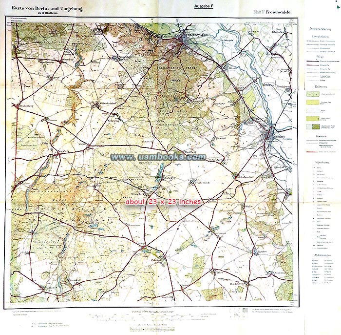
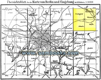
For sale on this USMBOOKS web page are THREE original Third Reich maps published by the Reichsamt für Landesaufnahme, the Nazi State Office for Geological Surveying at Wilhelmstrasse 9 in Berlin. These very detailed six-color 1:50,000 scale, single sheet approximately 23 x 23 inch maps were sold at bookstores during the Third Reich for one Reichsmark.
The huge scale of this Reichskarte or State Map (2 cm = 1 km!) makes it the perfect type for use by anyone researching anything to do with the area around Berlin. They show highways, country roads, forest roads, railways, churches, cemeteries, battlefields, memorials, forests, stone quarries, etc.
The maps are Blatt I for Nauen north of Potsdam, Blatt II for Oranienburg and Blatt IV for Freienwalde northeast of Berlin.


| • IF you prefer faster and safer Priority Mail shipping with USPS Tracking add $7.75. |
| • IF you wish to purchase highly recommended, but optional insurance, add $3.45. |
| • We will be happy to ship abroad at additional cost. Please inquire. |
| • IF you prefer faster and safer Priority Mail shipping with USPS Tracking add $7.35. |
| • IF you wish to purchase highly recommended, but optional insurance, add $3.50. |
| • We will be happy to ship abroad at additional cost. Please inquire. |

REICHSKARTE BERLIN UND UMGEBUNG, BLATT IV: FREIENWALDE
REICHSKARTE BERLIN UND UMGEBUNG, BLATT I: NAUEN
REICHSKARTE BERLIN UND UMGEBUNG, BLATT II: ORANIENBURG
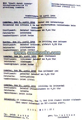
Inside the back cover is a hiking schedule suggested by the Hiking Department of the Kraft durch Freude (KdF or Strength through Joy) office in Berlin-Reinickendorf-West. It is for hikes in April 1944 and the sheet shows where to meet on what date, at what time, and the name of the person in charge of the hike (the Wanderführer). Above the words HEIL HITLER! is the announcement for the next area Heimabend on 4 May 1944 and at the bottom of the A4 sheet are the names of two Nazi Party members responsible, Kreiswanderwart Erich Bothe and Kreiswart Pg. Walther.
| • IF you prefer faster and safer Priority Mail shipping with USPS Tracking add $8.95. |
| • IF you wish to purchase highly recommended, but optional insurance, add $3.50. |
| • We will be happy to ship abroad at additional cost, however foreign customers are responsible for any VAT payments, import duties and clearing fees. Please inquire. |
Have a look at an early Nazi touring map of Berlin and the surrounding
area as well as other Third Reich maps for sale on USMBOOKS.com.
We are happy to combine shipping to save you money!
REICHSKARTE WITH NAZI EAGLE AND SWASTIKA COVER
BERLIN AND SURROUNDINGS: NAUEN ORANIENBURG FREIENWALDE